

In 1999, the Bank Street Shoreline Project was the first marine archaeological project coordinated by the Office of the State Archaeologist with the cooperation of recreational divers. Major waterfront development along Bank Street required that the City of New London prepare an "Archaeological Assessment and Documentation Survey" of the shoreline area. Under the direction of the State Archaeologist and private consultants, recreational divers volunteered to inspect the submerged portion of the project.
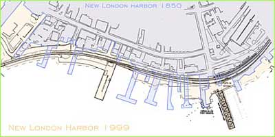
Map showing changes in harbor .
The Pequot Tribe had controlled the area, along with most of Connecticut's southern coast between the Thames and Pawcatuck Rivers, until their massacre at Mystic Fort in 1637. Shortly thereafter, European development of the Bank Street shoreline began and continues to the present. The hope of finding archaeological artifacts diminishes with the repeated dredging, filling, and building on an urban shoreline.
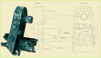
Rudder assembly (right) and glass bottles (below) excavated from the Bank Street site.

This was true for the Bank Street shoreline. No Native American and only a few European American underwater artifacts were found. The most significant of these was a six by twelve foot rudder section from a large vessel. A bronze pintle (hinge), the size of a small car engine, was attached to the rudder. Research indicated that the rudder was originally eight by sixteen feet and probably steered a mid 19th to early 20th century steamship, schooner, or whaler.
The success of this project was not measured in the number of finds. The partnership of the Office of the State Archaeologist and recreational divers set a precedent for mutual cooperation.